
Watershed Program
About the Watershed Program
The Watershed Program is a partnership between Harrison Soil & Water Conservation District (SWCD), Carroll SWCD, and Muskingum Watershed Conservancy District. The program is focused on maintaining and improving water quality in the watersheds of four lakes: Atwood, Leesville, Tappan, and Clendening. Through the Watershed Specialist position, the SWCD offices are working to monitor water quality, inventory resources, educate the public, and implement practices to benefit these watersheds.
|
|
Below are maps and specific information about each watershed. Additional details about each
watershed can be found in the Rapid Watershed Inventories, which can also be found below.
Atwood Lake Watershed | Leesville Lake Watershed | ||||
 |  | ||||
| The 70 square miles of the Atwood Lake Watershed in eastern Ohio are composed of two 12-digit hydrologic units, Pleasant Valley Run-Indian Fork (HUC 050400010802) and Cold Spring Run-Indian Fork (HUC 050400010801). The majority of the watershed is located in Carroll County with a small portion crossing into Tuscarawas County. The watershed had a population of 7,833 people as of 2010. The watershed is largely forested, with 26,210 acres of forest, followed by 12,768 acres of agricultural land, and 4,396 acres of urban areas. | The 50 square miles of the Leesville Lake Watershed in eastern Ohio are composed of two 12-digit hydrologic units, North Fork McGuire Creek (HUC 050400010705) and McGuire Creek (HUC 050400010706). The entire watershed is located in Carroll County. The watershed had a population of 2,222 people as of 2010. The watershed is largely forested, with 19,674 acres of forest, followed by 8,468 acres of agricultural land, and 1,587 acres of developed areas. | ||||
|
| ||||
Tappan Lake Watershed | Clendening Lake Watershed | ||||
 |  | ||||
| Tappan Lake Watershed makes up 71 square miles in Harrison county, Ohio. The watershed is composed of three 12-digit hydrologic units, Upper Little Stillwater Creek (HUC 050400011503), Clear Fork (HUC 050400011501), and Standingstone Fork (HUC 050400011502). The watershed had a population of 2,216 people as of 2010. The watersheds land use is dominated by the 33,280 acres of forest, has 7,040 acres of agricultural land, and 2,560 acres of urban areas. | Clendening Lake Watershed encompasses 70 square miles in eastern Ohio is a single 12-digit hydrologic unit, Brushy Fork (HUC 050400011402). The entire watershed is located in Harrison County. The watershed had a population of 2,589 people as of 2010. The watershed is largely forested, with 29,812 acres of forest, followed by 9,647 acres of agricultural land, and 2,382 acres of developed land. | ||||
|
| ||||
Water Quality Monitoring
The water quality monitoring program originated from a pilot program to monitor water quality in the upper section of the Atwood Lake Watershed in 2012. Monitoring continued in 2013 and the Watershed Specialist was hired in early 2014. The current monitoring program began in the fall of 2014. The primary goal of the monitoring program is to contribute to identifying areas of concern within the watersheds so that conservation efforts can be focused to those locations.
|
Projects
| Projects Must:
|
Education Programs
 | One part of the Watershed Program is to offer a wide range of educational experiences for youth or adult groups. The SWCD has several models that we can use to allow for visualization of complex concepts as well as access to numerous national curriculum on water quality related topics. Custom programs can also be developed on other water quality issues by request. To learn more about the education programs offered by the Harrison SWCD, view the HSWCD Conservation Education Guide . |
Resources
Below you will find various resources about water quality and watershed health.
 | Nutrients and Our Water Infographic This handout discusses the problem of nutrient pollution and its sources. It specifically looks at our local lakes and the potential issue of a Harmful Algal Bloom. | 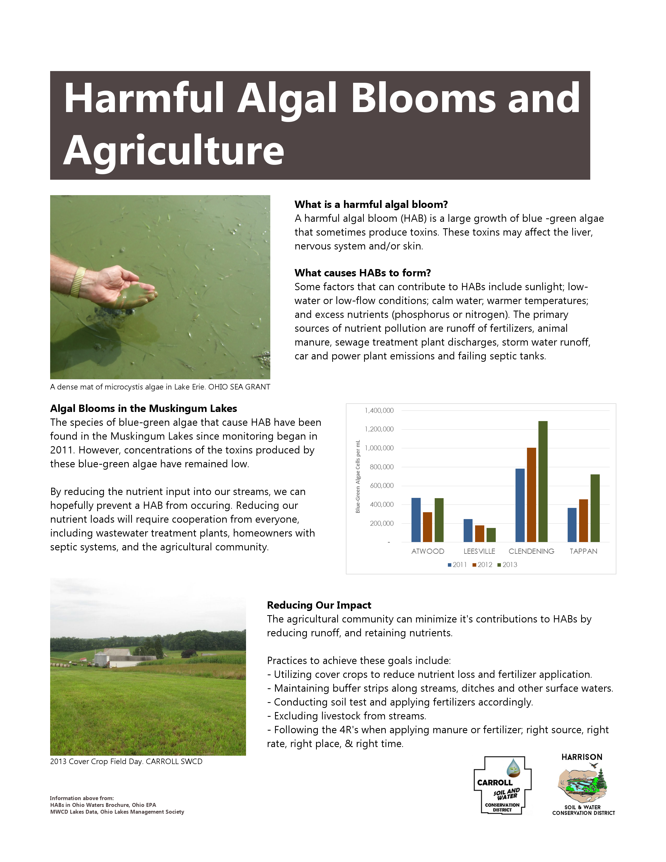 | Harmful Algal Blooms and Agriculture This handout explores the relationship between dangerous algal blooms and nutrient pollution from agricultural sources. |
| Interactive Watershed Map This tool can help landowners and residents identify whether their property falls within the Muskingum Watershed and see the watershed boundaries. | Blue-green algae invades inland lakes This article about algal blooms in our local lakes was published in the Farm and Dairy newspaper. |
External Links
| US Environmental Protection Agency - Watersheds Contains lots of information about watersheds and a watershed locator to learn which watershed you live in and the details about that watershed. | |
| Ohio Watershed Network Stay up to date on watershed issues by signing up for the Ohio Watershed Network mailing list. Also, includes the Know Your Well Water site to help understand water well testing results. | |
| Ohio Environmental Protection Agency - Muskingum River Watershed The Ohio EPA carries out regular monitoring of lakes, rivers, and streams across the state. This page holds the information available for the Muskingum River Watershed. | |
| Muskingum Watershed Conservancy District MWCD maintains the four lakes which are the focus of the watershed program. This site has details about the region and the flood control purpose of the reservoirs. |
Contact
Phone (Harrison Office): 740-942-8837
Phone (Carroll Office): 330-627-9852