
Trails
Harrison County has numerous trails offering a variety of opportunities for recreational pursuits and exploring our heritage.
This article provides an overview of the historical/ heritage and recreational trails in Harrison County, incorporating numerous historic sites and more than 100 miles of designated trails.
Many of Harrison County's trails are recreational in nature, offering hiking, biking, walking, rollerblading, and horseback riding opportunities. Others offer a route that enables us to drive from one historical site to another in an organized fashion. They all meander through the scenic rolling hills that make up the Harrison County landscape.
RECREATIONAL TRAILS
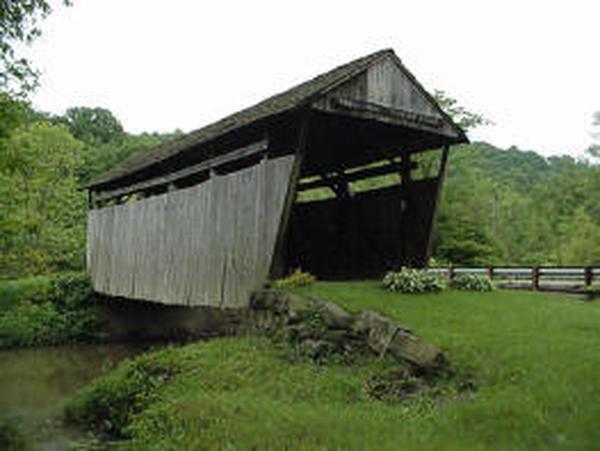
The Buckeye Trail is a 1,250 mile trail, primarily used for hiking, which makes a large loop around the State of Ohio. Nearly 42 miles of the trail are located in western Harrison County. The Buckeye Trail enters the county from the north at Bowerston and follows a route which crosses the dam at Tappan Lake and connects Tappan Lake, Clendening Lake, and Piedmont Lake before entering Guernsey County southwest of Freeport. Portions of the trail are open to horses on Muskingum Watershed Skull Fork BridgeConservancy District property at Tappan Lake. In the Freeport area the Buckeye Trail crosses the Skull Fork Covered Bridge and is a short hike on Skull Fork Road from what is believed to be the only 16 sided barn in Ohio. Much of the trail in southeastern Ohio is located on rural roads, and the Buckeye Trail Association is working to relocate these portions off road.
The Harrison State Forest, located in Archer Township, is a 1,344 acre recreational area which includes 24 miles of trails open to hikers and horseback riders. The property includes campsites, numerous fishing and hunting opportunities, and a shooting range. The property is managed by the Ohio Department of Natural Resources, Division of Forestry.
Sally Buffalo Park in Cadiz offers nearly a mile of trail for walking and bicycling for those in search of a quick "walk in the park." The trail circles the lake, passing Wallace Lodge and picnic areas.
Located at Deersville is Tappan Lake Park, operated by the Muskingum Watershed Conservancy District, which offers eight miles of hiking trails. Approximately six miles of the trails in the park form two loops that begin and end at the campgrounds. Additionally, there is a trail that begins near the beach area and travels east, incorporating some interesting wetland habitat.
The Harrison County Conotton Creek Trail connects Jewett, Scio, Conotton, and Bowerston. This 11.4 mile county owned facility is known as a "rail trail", since it is located on the former Wheeling and Lake Erie railroad bed. The trail has been paved from Jewett to Scio, and paving of the balance of the trail is expected to begin in a few weeks, once final government approvals are obtained. The trail is available for bicycling, hiking, and rollerblading, although the pavement surface is said to be a bit rough for rollerblading. If you have not visited the trail in awhile, a new feature is the covered bridge being constructed by the Scio American Legion at the Eastport Road crossing in Scio. Visit their page at https://www.facebook.com/groups/234744406632497/
The Ohio Department of Transportation has established a number of on road bicycle routes throughout the state. One of these routes, designated as the "J Route" connects Marietta and Conneaut, with approximately 25 miles of the route in Harrison County. This route enters the county on Route 149 south of New Athens and travels north on Route 9 from New Athens to Cadiz. From Cadiz it travels north on Route 9 to Lower Clearfork Road, to Dodson Road, to Hanover Ridge Road, to Scio. From Scio it continues north on Kilgore Ridge Road to Germantown Road, to McCue Road, and then north to Carrollton. (This is a hilly on road route which should be attempted only by well trained cyclists, and not by recreational riders.)
In addition to these public recreational trails, Harrison County has two private facilities that offer the public recreational trail opportunities. These are Faith Ranch, located south of Germano, with miles of bridle and hiking trails and Mickey's Mountain Bike course, which provides mountain biking events throughout the riding season.
There are 11,000 miles of rail trails across the nation, and the next focal point of development of these trails is connecting them to form trail systems. One of these efforts incorporates Harrison County. For more than a year there has been an effort ongoing which eventually will establish connectors that will unite developing trail systems in Ohio with trails in West Virginia and Pennsylvania. Key to the success of this effort is connecting the canal corridor which terminates at Zoarville to the Ohio River. There currently are two proposals on the drawing board, and they both include on road and off road routes through Harrison County. When completed, hopefully within the next several years, this trail system will provide a designated route connecting Cincinnati with Washington, DC, via Harrison County.
HERITAGE TRAILS
If your interests are scenery and history, rather than recreation, Harrison County has plenty to offer. No fewer than four heritage "trails" and a state scenic byway are located in the county.
The Tappan-Moravian Trail Ohio Scenic Byway is a designated route passing through the lake region and northern portions of the county. The route loops around Tappan Lake, passing through Deersville and Feed Springs, where two historic markers were installed recently. From the Tappan Lake area one branch of the byway follows Route 21 and Route 799 through the Clendening Lake region. Another branch follows Route 646 to Scio and New Rumley, before following Route 9 to Jewett and Route 151 back to Scio.
The Civil War Discovery Trail consists of a designation of sites of historical significance to Civil War history. The trail encompasses 27 states and includes 12 sites in Ohio. Among them is the General George Armstrong Custer Birthplace and Memorial in New Rumley.
The Underground Railroad Trail is a national "trail" which identifies sites involved in the organized effort to assist escaping slaves in making their way north to freedom. Two primary routes on the Underground Railroad intersected in eastern Harrison County. There are numerous sites involved with the effort in the county, including Delaney House in Hopedale which is owned by the Freedom Way Foundation, which has plans to renovate the property for use as an educational and cultural facility focusing on the Underground Railroad movement.
The Civil War in Eastern Ohio trail is a collaborative effort highlighting points of interest in Civil War history in the five county area of Harrison, Belmont, Jefferson, Carroll, and Columbiana. (Other counties may be added as the project evolves.) This program, coordinated by Dr. Lorle Porter of Muskingum College and Crossroads Resource Conservation and Development District, identifies points of interest in each of these counties and will promote them collectively, in the hope that they will be more attractive to visitors than if they are promoted individually. Harrison County sites include Franklin Museum, Clark Gable birthplace, Harrison Hills Cottage Industries, statues and historic sites at and near the Harrison County Courthouse, and the General George Armstrong Custer birthplace in New Rumley, as well as numerous historical markers throughout the county.
In July 1863, Confederate General John Hunt Morgan led his "Morgan's Raiders" on the deepest incursion of Confederate troops into Union territory during the course of the Civil War. Funding has been secured to establish "Morgan's Trail", which will follow the route of Morgan's Raid from Tennessee to their capture in Columbiana County. The trail will follow the route of Morgan's Raiders as they passed through southern Harrison County. The troops entered the county near Smyrna and traveled east, passing through Piedmont, Moorefield, Stumptown, Georgetown, and Harrisville. Funding will provide historic markers in Harrison County, in addition to the existing markers along Morgan's route.
MILLENNIUM TRAILS
The trails of Harrison County are not limited to local projects of importance only to our residents. The White House began the Millennium Trails program several years ago for the purpose of identifying and publicizing trails of national, state, and local significance throughout the country. There are 16 National Millennium trails designated as a part of this program, due to their national importance. Three of these trails travel through or incorporate points of interest in Harrison County. Two of these trails, the Underground Railroad Trail and the Civil War Discovery Trail are mentioned above. The third is the North Country Scenic Trail, which begins in North Dakota and travels 4,600 miles to its destination in New York state. This trail follows the route of the Buckeye Trail in this part of Ohio, passing through Harrison County before turning east at Zoar.
The White House program has designated one Millennium Heritage Trail in each of the 50 states. In Ohio that trail is the Buckeye Trail.
The Millennium Trails program has designated certain local trails as Community Millennium Trails, based on their cultural and historic significance. The Harrison County Conotton Creek Trail is one of approximately three dozen trails throughout Ohio to receive this designation by the White House.
WEBSITES
Listed below are some websites of interest regarding Harrison County trails.
ODOT Bicycle Route Map
http://www.dot.state.oh.us/bike/
Mickey's Mountain Bike Challenge
http://www.mickeysmtn.com
North Country Scenic Trail
http://www.northcountrytrail.org/
Faith Ranch
http://www.faithranch.org/
Buckeye Trail
http://www.buckeyetrail.org/
Millennium Trails Program
http://www.millenniumtrails.org/MT_active_pages/mt/main.asp
Ohio Historical Society
http://www.ohiohistory.org/